Geolocate

Les Borels topographic map

Click on the map to display elevation.

About this map
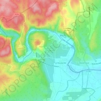
Name: Les Borels topographic map, elevation, terrain.

Location: Les Borels, Casteljau, Berrias-et-Casteljau, Largentière, Ardèche, Auvergne-Rhône-Alpes, France métropolitaine, 07460, France (44.37933 4.19298 44.41933 4.23298)

Average elevation: 164 m

Minimum elevation: 105 m

Maximum elevation: 255 m

Other topographic maps

Click on a map to view its topography, its elevation and its terrain.
Gear up for your next adventure:

🧣Merino Neck Gaiter - Protects against wind, sun, and cold at high altitudes
🧴Waterproofing Spray - Restore the DWR coating on jackets and tents
💧Hydration Pack - Hands-free hydration system for long hikes
🏕️Camping Hammock - Integrated protection for sleeping between trees
🛏️Camping Sleeping Mat - Comfortable mats for sleeping outdoors

As an Amazon Associate, this site earns from qualifying purchases at no extra cost to you.