
三水区 topographic map
Interactive map
Click on the map to display elevation.
About this map
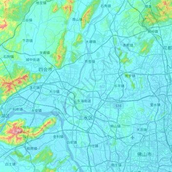
Name: 三水区 topographic map, elevation, terrain.
Location: 三水区, 佛山市, 广东省, 528100, 中国 (22.95876 112.75929 23.57619 113.05184)
Average elevation: 47 m
Minimum elevation: -7 m
Maximum elevation: 868 m
三水区的區域形狀狹長,南北最長為68公里,東西最寬為30.1公里,地勢自西北向東南傾斜,主要為丘陵、台地、平原區,且多積水洼地,西北多高丘,最高峰西平嶺海拔591米,東南多衝積平原及低丘。北江和西江在河口交匯。
Other topographic maps
Click on a map to view its topography, its elevation and its terrain.