
Make a donation
Gear up for your next adventure:
As an Amazon Associate, this site earns from qualifying purchases at no extra cost to you.
Huerta Grande topographic map
Click on the map to display elevation.
Make a donation
Gear up for your next adventure:
As an Amazon Associate, this site earns from qualifying purchases at no extra cost to you.
Huerta Grande
Además del balneario municipal, el cauce del río ofrece las piletas construidas sobre el mismo, a la sombra de añosos sauces de gran tamaño, y vigilando todo el paraje una enorme roca "El Peñón del Águila" con base granítica excavada por una cueva -una típica vivienda comechingona- siendo por su elevación un verdadero atalaya natural.
Make a donation
Gear up for your next adventure:
As an Amazon Associate, this site earns from qualifying purchases at no extra cost to you.
About this map
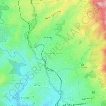
Name: Huerta Grande topographic map, elevation, terrain.
Average elevation: 1,005 m
Minimum elevation: 914 m
Maximum elevation: 1,181 m
Make a donation
Gear up for your next adventure:
As an Amazon Associate, this site earns from qualifying purchases at no extra cost to you.
Other topographic maps
Click on a map to view its topography, its elevation and its terrain.
Reserva Natural Vaquerías
Argentina > Córdoba > Pedanía San Antonio
La altitud dentro del predio varía entre los 800 y los 1400 m s. n. m.; en él existe un recorrido, de unos 3300 metros, que debe realizarse caminando y que conduce hasta El Diquecito. Desde allí se remonta el arroyo Vaquerías, hasta la llamada Garganta del Diablo, y luego por otro arroyo, se llega hasta la…
Average elevation: 1,132 m
Make a donation
Gear up for your next adventure:
As an Amazon Associate, this site earns from qualifying purchases at no extra cost to you.