
Folly Beach topographic map
Click on the map to display elevation.
About this map
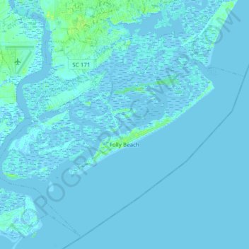
Name: Folly Beach topographic map, elevation, terrain.
Average elevation: 1 m
Minimum elevation: -3 m
Maximum elevation: 11 m
Other topographic maps
Click on a map to view its topography, its elevation and its terrain.
Sherwood Forest
United States > South Carolina > Charleston County > Charleston
Average elevation: 5 m
North Charleston
United States > South Carolina > Charleston County > North Charleston
Average elevation: 5 m
Gadsden Green Homes
United States > South Carolina > Charleston County > Charleston > Gadsden Green Homes
Average elevation: 4 m
Deerwood Heights
United States > South Carolina > Charleston County > North Charleston
Average elevation: 8 m