Geolocate

Gardiner topographic map

Click on the map to display elevation.

About this map

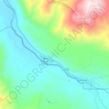
Name: Gardiner topographic map, elevation, terrain.

Location: Gardiner, Park County, Montana, United States (45.02949 -110.77238 45.07078 -110.68106)

Average elevation: 1,866 m

Minimum elevation: 1,560 m

Maximum elevation: 2,734 m

Gear up for your next adventure:

🚲Heavy Duty Bike Lock - Secure your bike at the trailhead or during stops
🧥Waterproof Pants - Keep dry during rainy hiking conditions
❄️Traction Ice Cleats - Slip-on spikes for icy trails and winter hiking
Lightweight Backpacking Tent - Compact tent for efficient hiking trips
🥾Trail Running Shoes - Lightweight and durable shoes for trail running

As an Amazon Associate, this site earns from qualifying purchases at no extra cost to you.