
Thank you for supporting this site ❤️
Make a donation
Make a donation
Gear up for your next adventure:
As an Amazon Associate, this site earns from qualifying purchases at no extra cost to you.
Copacabana topographic map
Click on the map to display elevation.
Thank you for supporting this site ❤️
Make a donation
Make a donation
Gear up for your next adventure:
As an Amazon Associate, this site earns from qualifying purchases at no extra cost to you.
About this map
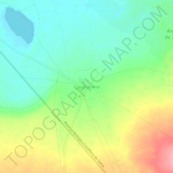
Name: Copacabana topographic map, elevation, terrain.
Average elevation: 3,678 m
Minimum elevation: 3,637 m
Maximum elevation: 3,747 m
Thank you for supporting this site ❤️
Make a donation
Make a donation
Gear up for your next adventure:
As an Amazon Associate, this site earns from qualifying purchases at no extra cost to you.
Other topographic maps
Click on a map to view its topography, its elevation and its terrain.
Arenales de Tajzara
Bolivia > Tarija > Provincia de José María Avilés > Municipio Yunchará > Copacabana
Average elevation: 3,689 m