
Thank you for supporting this site ❤️
Make a donation
Make a donation
Gear up for your next adventure:
As an Amazon Associate, this site earns from qualifying purchases at no extra cost to you.
Lascuarre topographic map
Click on the map to display elevation.
Thank you for supporting this site ❤️
Make a donation
Make a donation
Gear up for your next adventure:
As an Amazon Associate, this site earns from qualifying purchases at no extra cost to you.
About this map
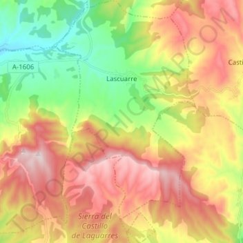
Name: Lascuarre topographic map, elevation, terrain.
Location: Lascuarre, La Ribagorza, Huesca, Aragón, España (42.13522 0.48217 42.22754 0.55389)
Average elevation: 828 m
Minimum elevation: 538 m
Maximum elevation: 1,145 m
Thank you for supporting this site ❤️
Make a donation
Make a donation
Gear up for your next adventure:
As an Amazon Associate, this site earns from qualifying purchases at no extra cost to you.