
Make a donation
Gear up for your next adventure:
As an Amazon Associate, this site earns from qualifying purchases at no extra cost to you.
Olne topographic map
Click on the map to display elevation.
Make a donation
Gear up for your next adventure:
As an Amazon Associate, this site earns from qualifying purchases at no extra cost to you.
Olne
La topographie d'Olne, son territoire bocager au nord, et son sud vallonné résultent de sa géologie : un socle argileux au nord qui draine l'eau vers les couches calcaires. Au fil des millénaires, ce socle dinantien s'effondre en chantoires, dolines et résurgences, typiques d'un paysage karstique.
Make a donation
Gear up for your next adventure:
As an Amazon Associate, this site earns from qualifying purchases at no extra cost to you.
About this map
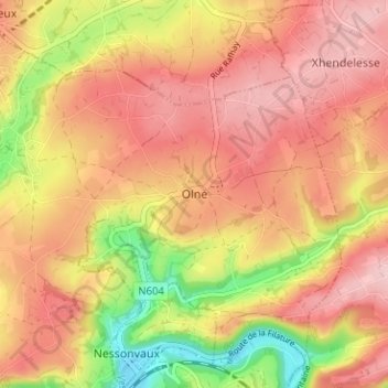
Name: Olne topographic map, elevation, terrain.
Location: Olne, Verviers, Liège, Wallonie, 4877, Belgique (50.57012 5.72799 50.61012 5.76799)
Average elevation: 217 m
Minimum elevation: 106 m
Maximum elevation: 285 m
Make a donation
Gear up for your next adventure:
As an Amazon Associate, this site earns from qualifying purchases at no extra cost to you.