Geolocate

Cuispes topographic map

Click on the map to display elevation.

About this map

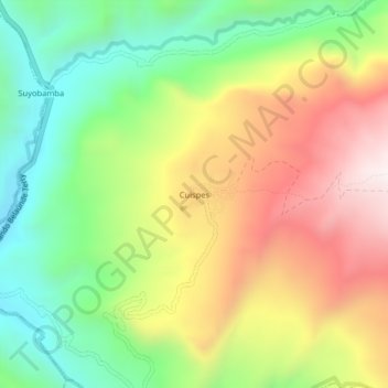
Name: Cuispes topographic map, elevation, terrain.

Location: Cuispes, Bongará, Amazonas, Perú (-5.94820 -77.96586 -5.90820 -77.92586)

Average elevation: 1,726 m

Minimum elevation: 1,338 m

Maximum elevation: 2,209 m

Gear up for your next adventure:

Camping Coffee Maker - Brew fresh coffee anywhere on the topographic map
👟Leg Gaiters - Keep debris, mud, and snow out of your boots
💧Hydration Bladder - Hands-free hydration solution for long treks
Camping Essentials - All-in-one gear for a comfortable camping trip
💡Portable Camping Lamp - Rechargeable lamp for campsite lighting

As an Amazon Associate, this site earns from qualifying purchases at no extra cost to you.