
Make a donation
Gear up for your next adventure:
As an Amazon Associate, this site earns from qualifying purchases at no extra cost to you.
Branderschrofen topographic map
Click on the map to display elevation.
Make a donation
Gear up for your next adventure:
As an Amazon Associate, this site earns from qualifying purchases at no extra cost to you.
About this map
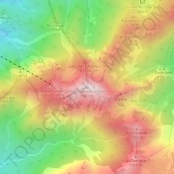
Name: Branderschrofen topographic map, elevation, terrain.
Average elevation: 1,423 m
Minimum elevation: 966 m
Maximum elevation: 1,860 m
Make a donation
Gear up for your next adventure:
As an Amazon Associate, this site earns from qualifying purchases at no extra cost to you.
Other topographic maps
Click on a map to view its topography, its elevation and its terrain.
Forggensee
Deutschland > Bayern > Landkreis Ostallgäu > Schwangau
Nach dem Höhepunkt der letzten Eiszeit schmolz der das ganze Ostallgäu bedeckende Lech-Wertach-Vorlandgletscher allmählich wieder von seinem Maximalstand bei Kaufbeuren zurück, wobei sich, wie im gesamten Voralpenbereich, am Rand der Gletscherzunge bei zwischenzeitlichen Stockungen oder erneutem Wachsen…
Average elevation: 821 m