
Make a donation
Gear up for your next adventure:
As an Amazon Associate, this site earns from qualifying purchases at no extra cost to you.
Zahle topographic map
Click on the map to display elevation.
Make a donation
Gear up for your next adventure:
As an Amazon Associate, this site earns from qualifying purchases at no extra cost to you.
Zahle
Zahlé is located 55 km (34 mi) east of the capital Beirut, close to the Beirut-Damascus road, and lies at the junction of the Lebanon mountains and the Beqaa plateau, at a mean elevation of 1,000 m. Zahlé is known as the "Bride of the Beqaa" and "the Neighbor of the Gorge" for its geographical location and attractiveness, but also as "the City of Wine and Poetry". Zahle is called "Dar el Salam" which means home of peace. It is famous throughout Lebanon and the region for its pleasant climate, numerous riverside restaurants and quality arak. Its inhabitants are predominantly Melkite Greek Catholic and are known in Arabic as Zahlawi.
Make a donation
Gear up for your next adventure:
As an Amazon Associate, this site earns from qualifying purchases at no extra cost to you.
About this map
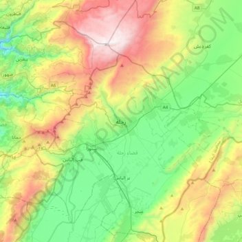
Name: Zahle topographic map, elevation, terrain.
Location: Zahle, Zahlé District, Beqaa Governorate, 1801, Lebanon (33.68765 35.74263 34.00765 36.06263)
Average elevation: 1,281 m
Minimum elevation: 562 m
Maximum elevation: 2,610 m
Make a donation
Gear up for your next adventure:
As an Amazon Associate, this site earns from qualifying purchases at no extra cost to you.