
Make a donation
Gear up for your next adventure:
As an Amazon Associate, this site earns from qualifying purchases at no extra cost to you.
La Détourbe topographic map
Click on the map to display elevation.
Make a donation
Gear up for your next adventure:
As an Amazon Associate, this site earns from qualifying purchases at no extra cost to you.
About this map
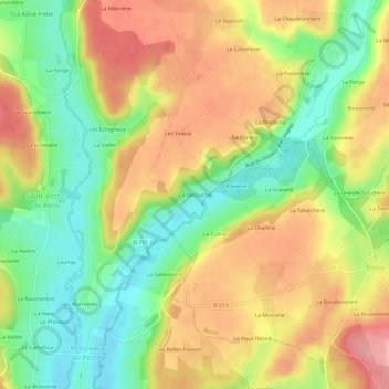
Name: La Détourbe topographic map, elevation, terrain.
Average elevation: 195 m
Minimum elevation: 140 m
Maximum elevation: 249 m
Make a donation
Gear up for your next adventure:
As an Amazon Associate, this site earns from qualifying purchases at no extra cost to you.
Other topographic maps
Click on a map to view its topography, its elevation and its terrain.
Make a donation
Gear up for your next adventure:
As an Amazon Associate, this site earns from qualifying purchases at no extra cost to you.
Monceaux-au-Perche
France > Normandie > Orne > Longny les Villages
La superficie de Monceaux-au-Perche est de 3,15 km2 ; son altitude varie de 137 à 227 mètres.
Average elevation: 198 m