
Make a donation
Gear up for your next adventure:
As an Amazon Associate, this site earns from qualifying purchases at no extra cost to you.
Sayre topographic map
Click on the map to display elevation.
Make a donation
Gear up for your next adventure:
As an Amazon Associate, this site earns from qualifying purchases at no extra cost to you.
About this map
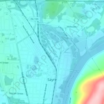
Name: Sayre topographic map, elevation, terrain.
Location: Sayre, Bradford County, Pennsylvania, United States (41.97247 -76.53696 41.99983 -76.50455)
Average elevation: 251 m
Minimum elevation: 227 m
Maximum elevation: 409 m
Make a donation
Gear up for your next adventure:
As an Amazon Associate, this site earns from qualifying purchases at no extra cost to you.
Other topographic maps
Click on a map to view its topography, its elevation and its terrain.
North Towanda
United States > Pennsylvania > Bradford County > North Towanda Township
Average elevation: 286 m
Gillett
United States > Pennsylvania > Bradford County > South Creek Township
Average elevation: 470 m
Allis Hollow
United States > Pennsylvania > Bradford County > Orwell Township
Average elevation: 348 m
Make a donation
Gear up for your next adventure:
As an Amazon Associate, this site earns from qualifying purchases at no extra cost to you.
Stevensville
United States > Pennsylvania > Bradford County > Stevens Township
Average elevation: 328 m
Bentley Creek
United States > Pennsylvania > Bradford County > Ridgebury Township
Average elevation: 417 m
Springfield
United States > Pennsylvania > Bradford County > Springfield Township
Average elevation: 442 m
Ridgebury
United States > Pennsylvania > Bradford County > Ridgebury Township
Average elevation: 394 m
Make a donation
Gear up for your next adventure:
As an Amazon Associate, this site earns from qualifying purchases at no extra cost to you.
Lake Nephawin
United States > Pennsylvania > Bradford County > Canton Township
Average elevation: 472 m