
Make a donation
Gear up for your next adventure:
As an Amazon Associate, this site earns from qualifying purchases at no extra cost to you.
Plattenhausenriegel topographic map
Click on the map to display elevation.
Make a donation
Gear up for your next adventure:
As an Amazon Associate, this site earns from qualifying purchases at no extra cost to you.
Plattenhausenriegel
Über den Plattenhausenriegel (tschechisch Blatný vrch) im Bayerischen Wald läuft die Grenze des Landkreises Freyung-Grafenau in Bayern zu Tschechien, er liegt zwischen dem Großen Rachel (1453 m) im Westnordwesten und dem Lusen (1373 m) im Südosten und ist nach der aktuellen Topographischen Karte Bayerns 1372 m ü. NHN[1] hoch; in den meisten Karten ist für den Berg jedoch eine Höhe von 1376 m eingetragen.
Make a donation
Gear up for your next adventure:
As an Amazon Associate, this site earns from qualifying purchases at no extra cost to you.
About this map
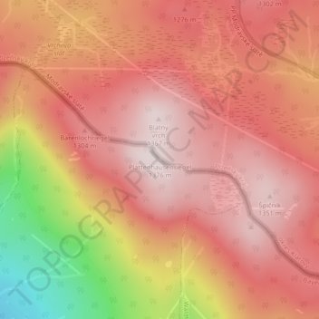
Name: Plattenhausenriegel topographic map, elevation, terrain.
Average elevation: 1,217 m
Minimum elevation: 859 m
Maximum elevation: 1,377 m
Make a donation
Gear up for your next adventure:
As an Amazon Associate, this site earns from qualifying purchases at no extra cost to you.