
Thank you for supporting this site ❤️
Make a donation
Make a donation
Gear up for your next adventure:
As an Amazon Associate, this site earns from qualifying purchases at no extra cost to you.
Z. 5 MX topographic map
Click on the map to display elevation.
Thank you for supporting this site ❤️
Make a donation
Make a donation
Gear up for your next adventure:
As an Amazon Associate, this site earns from qualifying purchases at no extra cost to you.
About this map
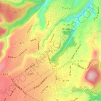
Name: Z. 5 MX topographic map, elevation, terrain.
Location: Z. 5 MX, Mixco, Guatemala, 010576, Guatemala (14.64503 -90.59136 14.68503 -90.55136)
Average elevation: 1,577 m
Minimum elevation: 1,429 m
Maximum elevation: 1,689 m
Thank you for supporting this site ❤️
Make a donation
Make a donation
Gear up for your next adventure:
As an Amazon Associate, this site earns from qualifying purchases at no extra cost to you.