
Make a donation
Gear up for your next adventure:
As an Amazon Associate, this site earns from qualifying purchases at no extra cost to you.
Woltersdorf topographic map
Click on the map to display elevation.
Make a donation
Gear up for your next adventure:
As an Amazon Associate, this site earns from qualifying purchases at no extra cost to you.
Woltersdorf
Woltersdorf liegt im Wendland innerhalb des Naturpark Elbhöhen-Wendland. Nördlich des Ortes verläuft der nach Nordwesten hin abfließende Luciekanal. Die Gemeinde gehört der Samtgemeinde Lüchow (Wendland) an, die ihren Verwaltungssitz in der Stadt Lüchow (Wendland) hat.
Make a donation
Gear up for your next adventure:
As an Amazon Associate, this site earns from qualifying purchases at no extra cost to you.
About this map
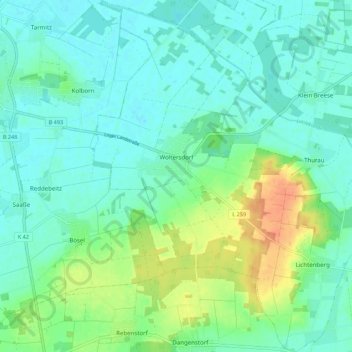
Name: Woltersdorf topographic map, elevation, terrain.
Average elevation: 25 m
Minimum elevation: 13 m
Maximum elevation: 56 m
Make a donation
Gear up for your next adventure:
As an Amazon Associate, this site earns from qualifying purchases at no extra cost to you.