
Make a donation
Gear up for your next adventure:
As an Amazon Associate, this site earns from qualifying purchases at no extra cost to you.
L'Essert topographic map
Click on the map to display elevation.
Make a donation
Gear up for your next adventure:
As an Amazon Associate, this site earns from qualifying purchases at no extra cost to you.
About this map
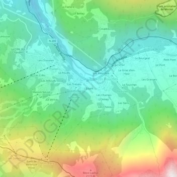
Name: L'Essert topographic map, elevation, terrain.
Average elevation: 1,327 m
Minimum elevation: 853 m
Maximum elevation: 2,390 m
Make a donation
Gear up for your next adventure:
As an Amazon Associate, this site earns from qualifying purchases at no extra cost to you.
Other topographic maps
Click on a map to view its topography, its elevation and its terrain.
Glacier de Taconnaz
France > Auvergne-Rhône-Alpes > Haute-Savoie > Les Houches
Le glacier de Taconnaz se trouve dans le massif du Mont-Blanc, au-dessus de la vallée de Chamonix, entre le glacier des Bossons à l'est et celui du Bourgeat à l'ouest, sous l'aiguille et le dôme du Goûter et au-dessus des hameaux de Taconnaz aux Houches et des Montquarts à Chamonix-Mont-Blanc. Les glaces…
Average elevation: 2,769 m