
Thank you for supporting this site ❤️
Make a donation
Make a donation
Gear up for your next adventure:
As an Amazon Associate, this site earns from qualifying purchases at no extra cost to you.
Tembladera topographic map
Click on the map to display elevation.
Thank you for supporting this site ❤️
Make a donation
Make a donation
Gear up for your next adventure:
As an Amazon Associate, this site earns from qualifying purchases at no extra cost to you.
About this map
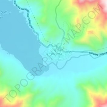
Name: Tembladera topographic map, elevation, terrain.
Location: Tembladera, Yonán, Provincia de Contumazá, Cajamarca, Perú (-7.27318 -79.15079 -7.23318 -79.11079)
Average elevation: 530 m
Minimum elevation: 389 m
Maximum elevation: 1,027 m
Thank you for supporting this site ❤️
Make a donation
Make a donation
Gear up for your next adventure:
As an Amazon Associate, this site earns from qualifying purchases at no extra cost to you.