
Make a donation
Gear up for your next adventure:
As an Amazon Associate, this site earns from qualifying purchases at no extra cost to you.
Griswold topographic map
Click on the map to display elevation.
Make a donation
Gear up for your next adventure:
As an Amazon Associate, this site earns from qualifying purchases at no extra cost to you.
About this map
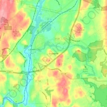
Name: Griswold topographic map, elevation, terrain.
Average elevation: 63 m
Minimum elevation: 19 m
Maximum elevation: 119 m
Make a donation
Gear up for your next adventure:
As an Amazon Associate, this site earns from qualifying purchases at no extra cost to you.
Other topographic maps
Click on a map to view its topography, its elevation and its terrain.
Central Waterford CDP
United States > Connecticut > Southeastern Connecticut Planning Region > Waterford
Average elevation: 22 m
Baltic
United States > Connecticut > Southeastern Connecticut Planning Region > Sprague
Average elevation: 81 m
Pawcatuck
United States > Connecticut > Southeastern Connecticut Planning Region > Stonington
Average elevation: 26 m
Avery Pond
United States > Connecticut > Southeastern Connecticut Planning Region > Preston
Average elevation: 51 m
Make a donation
Gear up for your next adventure:
As an Amazon Associate, this site earns from qualifying purchases at no extra cost to you.
New London County
United States > Connecticut > Southeastern Connecticut Planning Region
Average elevation: 73 m
Montville
United States > Connecticut > Southeastern Connecticut Planning Region
Average elevation: 80 m
Niantic
United States > Connecticut > Southeastern Connecticut Planning Region > East Lyme > Niantic
Average elevation: 12 m
Avon Place/Fieldcrest Play Area
United States > Connecticut > Southeastern Connecticut Planning Region > Groton > Old Mystic
Average elevation: 36 m
Make a donation
Gear up for your next adventure:
As an Amazon Associate, this site earns from qualifying purchases at no extra cost to you.
Fort Trumbull State Park
United States > Connecticut > Southeastern Connecticut Planning Region > New London
Average elevation: 12 m
Franklin Park
United States > Connecticut > Southeastern Connecticut Planning Region > Norwich
Average elevation: 39 m
Sprague
United States > Connecticut > Southeastern Connecticut Planning Region
Average elevation: 77 m
Poquonock Bridge
United States > Connecticut > Southeastern Connecticut Planning Region > Groton > Poquonock Bridge
Average elevation: 20 m
Make a donation
Gear up for your next adventure:
As an Amazon Associate, this site earns from qualifying purchases at no extra cost to you.