
Make a donation
Gear up for your next adventure:
As an Amazon Associate, this site earns from qualifying purchases at no extra cost to you.
Taza topographic map
Click on the map to display elevation.
Make a donation
Gear up for your next adventure:
As an Amazon Associate, this site earns from qualifying purchases at no extra cost to you.
Taza
Taza is located in north-central Morocco, in the south of the Rif region right outside the mountain range on a narrow plain. The city is composed of two formerly separate towns built on separate terraces overlooking a mountain valley. The old-Taza town is at an elevation of 1,919 feet (585 m) above sea level and is surrounded by fortifications; the newer town, established by the French in 1920, is located in a fertile plain at an elevation of 1,460 feet (445 m). Fossil remains indicate that caves in the area were inhabited as early as the Paleolithic Period. One of the most important caves in Morocco, Rhar Chara, is close to Taza. This cave is over 7.6 kilometres long.
Make a donation
Gear up for your next adventure:
As an Amazon Associate, this site earns from qualifying purchases at no extra cost to you.
About this map
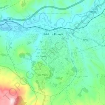
Name: Taza topographic map, elevation, terrain.
Average elevation: 536 m
Minimum elevation: 409 m
Maximum elevation: 990 m
Make a donation
Gear up for your next adventure:
As an Amazon Associate, this site earns from qualifying purchases at no extra cost to you.