
Make a donation
Gear up for your next adventure:
As an Amazon Associate, this site earns from qualifying purchases at no extra cost to you.
Georgenthal topographic map
Click on the map to display elevation.
Make a donation
Gear up for your next adventure:
As an Amazon Associate, this site earns from qualifying purchases at no extra cost to you.
About this map
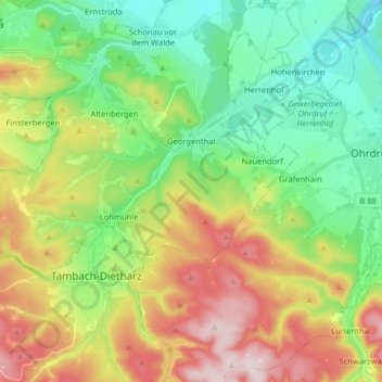
Name: Georgenthal topographic map, elevation, terrain.
Location: Georgenthal, Landkreis Gotha, Thüringen, Deutschland (50.79299 10.54156 50.84084 10.70168)
Average elevation: 523 m
Minimum elevation: 342 m
Maximum elevation: 766 m
Make a donation
Gear up for your next adventure:
As an Amazon Associate, this site earns from qualifying purchases at no extra cost to you.
Other topographic maps
Click on a map to view its topography, its elevation and its terrain.
Schönau vor dem Walde
Deutschland > Thüringen > Landkreis Gotha > Georgenthal > Schönau vor dem Walde
Average elevation: 387 m
Wipperoda
Deutschland > Thüringen > Landkreis Gotha > Georgenthal > Wipperoda
Average elevation: 357 m