Geolocate

Chuspiri topographic map

Click on the map to display elevation.

About this map

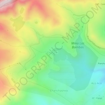
Name: Chuspiri topographic map, elevation, terrain.

Location: Chuspiri, Challhuahuacho, Cotabambas, Apurímac, Perú (-14.10134 -72.34648 -14.06134 -72.30648)

Average elevation: 4,182 m

Minimum elevation: 3,884 m

Maximum elevation: 4,628 m

Gear up for your next adventure:

🔋Solar Power Bank - Keep your GPS and devices charged during long outdoor trips
🔭Outdoor Binoculars - Lightweight binoculars for birdwatching and hiking
🕯️Camping Lantern - Illuminates your entire campsite with high-efficiency LEDs
🧭GPS Outdoor Watch - Smart watch for navigation and fitness tracking in nature
💧Hydration Bladder - Hands-free hydration solution for long treks

As an Amazon Associate, this site earns from qualifying purchases at no extra cost to you.