Geolocate

Alsenberg topographic map

Click on the map to display elevation.

About this map

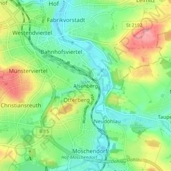
Name: Alsenberg topographic map, elevation, terrain.

Location: Alsenberg, Hof, Bayern, 95032, Deutschland (50.28271 11.90957 50.32271 11.94957)

Average elevation: 510 m

Minimum elevation: 473 m

Maximum elevation: 576 m

Other topographic maps

Click on a map to view its topography, its elevation and its terrain.

95030

Deutschland > Bayern > Hof

Average elevation: 525 m

95028

Deutschland > Bayern > Hof

Average elevation: 514 m

Saale

Deutschland > Bayern > Hof > Unterkotzau

Average elevation: 505 m

Gear up for your next adventure:

🧥Waterproof Pants - Keep dry during rainy hiking conditions
💡Solar Camping Lamp - Eco-friendly lighting for campsites
🥾Light Hiking Boots - Lightweight and comfortable boots for day hikes
🩹Compact First Aid Kit - Pre-packed essentials for common trail injuries
🧭GPS Outdoor Watch - Smart watch for navigation and fitness tracking in nature

As an Amazon Associate, this site earns from qualifying purchases at no extra cost to you.