Geolocate

Graham topographic map

Click on the map to display elevation.

About this map

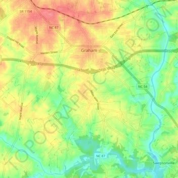
Name: Graham topographic map, elevation, terrain.

Location: Graham, Alamance County, North Carolina, 27352, United States (36.01642 -79.43280 36.08871 -79.33954)

Average elevation: 174 m

Minimum elevation: 140 m

Maximum elevation: 211 m

Other topographic maps

Click on a map to view its topography, its elevation and its terrain.

Glencoe

United States > North Carolina > Alamance County

Average elevation: 184 m

Elon

United States > North Carolina > Alamance County > Elon

Average elevation: 201 m

Gear up for your next adventure:

🛰️Satellite Messenger - Emergency communication for areas with no cell service
🐕Hiking Dog Pack - Let your canine companion carry their own water and food
🌡️Emergency Mylar Blankets - Compact thermal protection for unexpected nights outdoors
🩹Compact First Aid Kit - Pre-packed essentials for common trail injuries
🧣Evaporative Cooling Towel - Beat the heat during intense summer climbs

As an Amazon Associate, this site earns from qualifying purchases at no extra cost to you.