
Make a donation
Gear up for your next adventure:
As an Amazon Associate, this site earns from qualifying purchases at no extra cost to you.
Le Charpen topographic map
Click on the map to display elevation.
Make a donation
Gear up for your next adventure:
As an Amazon Associate, this site earns from qualifying purchases at no extra cost to you.
About this map
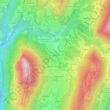
Name: Le Charpen topographic map, elevation, terrain.
Average elevation: 685 m
Minimum elevation: 253 m
Maximum elevation: 1,251 m
Make a donation
Gear up for your next adventure:
As an Amazon Associate, this site earns from qualifying purchases at no extra cost to you.
Other topographic maps
Click on a map to view its topography, its elevation and its terrain.
La Vence
France > Auvergne-Rhône-Alpes > Isère > Quaix-en-Chartreuse
D'une longueur de 17,2 kilomètres, la Vence naît dans le massif de la Chartreuse, à la limite des communes de Saint-Pancrasse et Le Sappey-en-Chartreuse, à environ 1 900 m d'altitude, sur la face orientale de Chamechaude (2 082 m).
Average elevation: 810 m