
Make a donation
Gear up for your next adventure:
As an Amazon Associate, this site earns from qualifying purchases at no extra cost to you.
Beaver Creek topographic map
Click on the map to display elevation.
Make a donation
Gear up for your next adventure:
As an Amazon Associate, this site earns from qualifying purchases at no extra cost to you.
About this map
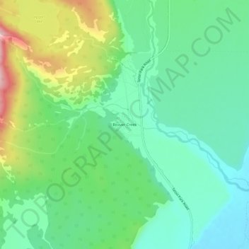
Name: Beaver Creek topographic map, elevation, terrain.
Location: Beaver Creek, Teton County, Wyoming, 83012, United States (43.66715 -110.75549 43.70715 -110.71549)
Average elevation: 2,043 m
Minimum elevation: 1,972 m
Maximum elevation: 2,201 m
Make a donation
Gear up for your next adventure:
As an Amazon Associate, this site earns from qualifying purchases at no extra cost to you.
Other topographic maps
Click on a map to view its topography, its elevation and its terrain.
Make a donation
Gear up for your next adventure:
As an Amazon Associate, this site earns from qualifying purchases at no extra cost to you.
Alta
United States > Wyoming > Teton County
Alta is located just east of the Idaho state line, approximately 5 miles (8 km) east of Driggs, at an elevation of 6,440 feet (1,963 m) above sea level.
Average elevation: 2,477 m