
Make a donation
Gear up for your next adventure:
As an Amazon Associate, this site earns from qualifying purchases at no extra cost to you.
Rabka-Zdrój topographic map
Click on the map to display elevation.
Make a donation
Gear up for your next adventure:
As an Amazon Associate, this site earns from qualifying purchases at no extra cost to you.
About this map
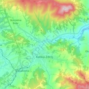
Name: Rabka-Zdrój topographic map, elevation, terrain.
Average elevation: 594 m
Minimum elevation: 422 m
Maximum elevation: 1,007 m
Make a donation
Gear up for your next adventure:
As an Amazon Associate, this site earns from qualifying purchases at no extra cost to you.
Other topographic maps
Click on a map to view its topography, its elevation and its terrain.
Pieniny
Poland > Lesser Poland Voivodeship > Nowy Targ County > Sromowce Niżne
Average elevation: 633 m
Three Crowns
Poland > Lesser Poland Voivodeship > Nowy Targ County > Sromowce Niżne > Koniec
Average elevation: 639 m
Make a donation
Gear up for your next adventure:
As an Amazon Associate, this site earns from qualifying purchases at no extra cost to you.
Obidowa
Poland > Lesser Poland Voivodeship > Nowy Targ County
The summit of Turbacz has a subarctic climate (Köppen Dfc) due to its elevation. The average temperatures are comparable with those found in places in far Northern Europe, such as Alta, Norway, however, the high annual precipitation in combination with the low temperatures places it firmly within the…
Average elevation: 1,117 m
Pieniny
Poland > Lesser Poland Voivodeship > Nowy Targ County > Sromowce Niżne
Average elevation: 632 m
Make a donation
Gear up for your next adventure:
As an Amazon Associate, this site earns from qualifying purchases at no extra cost to you.