
Make a donation
Gear up for your next adventure:
As an Amazon Associate, this site earns from qualifying purchases at no extra cost to you.
Raon Basse topographic map
Click on the map to display elevation.
Make a donation
Gear up for your next adventure:
As an Amazon Associate, this site earns from qualifying purchases at no extra cost to you.
About this map
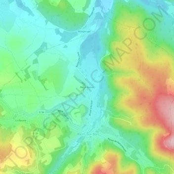
Name: Raon Basse topographic map, elevation, terrain.
Average elevation: 454 m
Minimum elevation: 383 m
Maximum elevation: 594 m
Make a donation
Gear up for your next adventure:
As an Amazon Associate, this site earns from qualifying purchases at no extra cost to you.
Other topographic maps
Click on a map to view its topography, its elevation and its terrain.
Ruisseau la Niche
France > Grand Est > Vosges > Raon-aux-Bois
La Niche prend sa source dans la forêt de Humont (à environ 590 m d'altitude) à l'étang de La Broche d'Avaux, en limite des communes de Bellefontaine et de Saint-Nabord. Elle fait partie du grand bassin versant Rhin-Meuse-Moselle.
Average elevation: 480 m