
Lublin topographic map
Interactive map
Click on the map to display elevation.
About this map
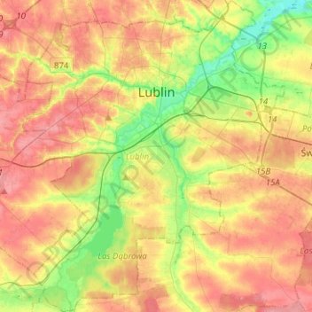
Name: Lublin topographic map, elevation, terrain.
Location: Lublin, Lublin Voivodeship, Poland (51.13981 22.45379 51.29656 22.67354)
Average elevation: 202 m
Minimum elevation: 159 m
Maximum elevation: 240 m
Other topographic maps
Click on a map to view its topography, its elevation and its terrain.
Woroblin
Poland > Lublin Voivodeship > Biała Podlaska County
Woroblin, gmina Janów Podlaski, Biała Podlaska County, Lublin Voivodeship, Poland
Average elevation: 127 m
Zamość County
Zamość County, Lublin Voivodeship, Poland
Average elevation: 245 m
Biała Podlaska
Poland > Lublin Voivodeship > Biała Podlaska County > Wólka Plebańska
Biała Podlaska, Wólka Plebańska, Biała Podlaska County, Lublin Voivodeship, 21-500, Poland
Average elevation: 146 m
Ujazdów
Poland > Lublin Voivodeship > Zamość County
Ujazdów, gmina Nielisz, Zamość County, Lublin Voivodeship, Poland
Average elevation: 210 m
Tomaszów Lubelski County
Tomaszów Lubelski County, Lublin Voivodeship, Poland
Average elevation: 242 m
Biłgoraj
Poland > Lublin Voivodeship > Biłgoraj County
Biłgoraj, Biłgoraj County, Lublin Voivodeship, 23-400, Poland
Average elevation: 199 m
Suszeń
Poland > Lublin Voivodeship > Krasnystaw County
Suszeń, gmina Rudnik, Krasnystaw County, Lublin Voivodeship, Poland
Average elevation: 266 m
Bródki
Poland > Lublin Voivodeship > Zamość County > Jacnia
Bródki, Jacnia, gmina Adamów, Zamość County, Lublin Voivodeship, 22-442, Poland
Average elevation: 288 m
Chełm County
Chełm County, Lublin Voivodeship, Poland
Average elevation: 203 m
Zajączków
Poland > Lublin Voivodeship > Zajączków
Zajączków, gmina Opole Lubelskie, Opole Lubelskie County, Lublin Voivodeship, Poland
Average elevation: 151 m
Dęblin
Poland > Lublin Voivodeship > Dęblin
Dęblin, Ryki County, Lublin Voivodeship, Poland
Average elevation: 120 m
Puławy County
Puławy County, Lublin Voivodeship, Poland
Average elevation: 159 m
Krasnystaw County
Krasnystaw County, Lublin Voivodeship, Poland
Average elevation: 221 m
Lubartów County
Lubartów County, Lublin Voivodeship, Poland
Average elevation: 164 m
Terespol
Poland > Lublin Voivodeship > Terespol
Terespol, Biała Podlaska County, Lublin Voivodeship, Poland
Average elevation: 133 m
Zamość
Poland > Lublin Voivodeship > Zamość
Zamość, Lublin Voivodeship, Poland
Average elevation: 213 m
Zagórzany
Poland > Lublin Voivodeship > Zagórzany
Zagórzany, gmina Józefów, powiat biłgorajski, Lublin Voivodeship, Poland
Average elevation: 265 m
Kraśnik
Poland > Lublin Voivodeship > Kraśnik
Kraśnik, powiat kraśnicki, Lublin Voivodeship, Poland
Average elevation: 232 m
Annopol
Poland > Lublin Voivodeship > Annopol > Annopol
Annopol, gmina Annopol, Kraśnik County, Lublin Voivodeship, 23-235, Poland
Average elevation: 169 m
Bieszczady
Poland > Lublin Voivodeship > Luchów Górny
Bieszczady, Luchów Górny, gmina Tarnogród, powiat biłgorajski, Lublin Voivodeship, 23-420, Poland
Average elevation: 239 m
Nałęczów
Poland > Lublin Voivodeship > Nałęczów > Nałęczów
Nałęczów, gmina Nałęczów, Puławy County, Lublin Voivodeship, 24-140, Poland
Average elevation: 194 m
Tomaszów Lubelski
Poland > Lublin Voivodeship > Tomaszów Lubelski
Tomaszów Lubelski, powiat tomaszowski, Lublin Voivodeship, 22-600, Poland
Average elevation: 281 m
Krasnystaw
Poland > Lublin Voivodeship > Krasnystaw
Krasnystaw, powiat krasnostawski, Lublin Voivodeship, 22-300, Poland
Average elevation: 201 m