
Ujazdów topographic map
Interactive map
Click on the map to display elevation.
About this map
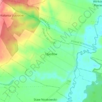
Name: Ujazdów topographic map, elevation, terrain.
Average elevation: 210 m
Minimum elevation: 182 m
Maximum elevation: 260 m
Other topographic maps
Click on a map to view its topography, its elevation and its terrain.
Bródki
Poland > Lublin Voivodeship > Zamość County > Jacnia
Bródki, Jacnia, gmina Adamów, Zamość County, Lublin Voivodeship, 22-442, Poland
Average elevation: 288 m