
Make a donation
Gear up for your next adventure:
As an Amazon Associate, this site earns from qualifying purchases at no extra cost to you.
Rehburg topographic map
Click on the map to display elevation.
Make a donation
Gear up for your next adventure:
As an Amazon Associate, this site earns from qualifying purchases at no extra cost to you.
Rehburg
Die Entfernung Rehburg nach Hannover und Bremen beträgt etwa 45 bzw. 105 km. Das Siedlungsgebiet hat die Form eines Straßendorfes, es wird im Norden durch ein ausgedehntes Wald- und Moorgebiet begrenzt, im Süden und Südwesten durch den Höhenzug der Rehburger Berge und im Osten durch das Steinhuder Meer. In den restlichen Himmelsrichtungen befindet sich Weide- und Wiesenlandschaft. Rehburg wird auch vom Steinhuder Meerbach in Ost-West-Richtung durchflossen.
Make a donation
Gear up for your next adventure:
As an Amazon Associate, this site earns from qualifying purchases at no extra cost to you.
About this map
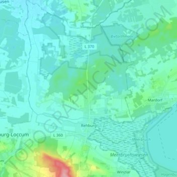
Name: Rehburg topographic map, elevation, terrain.
Average elevation: 43 m
Minimum elevation: 29 m
Maximum elevation: 139 m
Make a donation
Gear up for your next adventure:
As an Amazon Associate, this site earns from qualifying purchases at no extra cost to you.
Other topographic maps
Click on a map to view its topography, its elevation and its terrain.
Pennigsehl
Deutschland > Niedersachsen > Landkreis Nienburg/Weser > Pennigsehl > Pennigsehl
Average elevation: 54 m
Make a donation
Gear up for your next adventure:
As an Amazon Associate, this site earns from qualifying purchases at no extra cost to you.
Make a donation
Gear up for your next adventure:
As an Amazon Associate, this site earns from qualifying purchases at no extra cost to you.
Make a donation
Gear up for your next adventure:
As an Amazon Associate, this site earns from qualifying purchases at no extra cost to you.
Haßberger Hauptgraben
Deutschland > Niedersachsen > Landkreis Nienburg/Weser > Gandesbergen
Average elevation: 22 m