
Make a donation
Gear up for your next adventure:
As an Amazon Associate, this site earns from qualifying purchases at no extra cost to you.
Mendaur topographic map
Click on the map to display elevation.
Make a donation
Gear up for your next adventure:
As an Amazon Associate, this site earns from qualifying purchases at no extra cost to you.
Mendaur
Mendaur est un sommet de Navarre, sur la commune d'Ituren et, plus précisément, au hameau d'Aurtiz. Il culmine à 1 130 m d'altitude. Une chapelle a été édifiée en 1692, restaurée en 1963. C'est une montagne emblématique pour les habitants de la vallée de Malerreka.
Make a donation
Gear up for your next adventure:
As an Amazon Associate, this site earns from qualifying purchases at no extra cost to you.
About this map
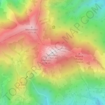
Name: Mendaur topographic map, elevation, terrain.
Location: Mendaur, Ituren, Baztan-Bidasoa, Navarre, 31745, Espagne (43.15540 -1.71934 43.15550 -1.71924)
Average elevation: 722 m
Minimum elevation: 326 m
Maximum elevation: 1,108 m
Make a donation
Gear up for your next adventure:
As an Amazon Associate, this site earns from qualifying purchases at no extra cost to you.