
Thank you for supporting this site ❤️
Make a donation
Make a donation
Gear up for your next adventure:
As an Amazon Associate, this site earns from qualifying purchases at no extra cost to you.
Udaipur topographic map
Click on the map to display elevation.
Thank you for supporting this site ❤️
Make a donation
Make a donation
Gear up for your next adventure:
As an Amazon Associate, this site earns from qualifying purchases at no extra cost to you.
About this map
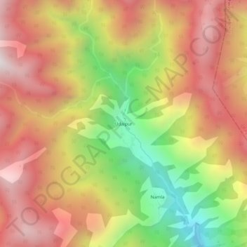
Name: Udaipur topographic map, elevation, terrain.
Location: Udaipur, Tharali, Chamoli district, Uttarakhand, Inde (30.06737 79.74174 30.10737 79.78174)
Average elevation: 2,566 m
Minimum elevation: 1,795 m
Maximum elevation: 3,168 m
Thank you for supporting this site ❤️
Make a donation
Make a donation
Gear up for your next adventure:
As an Amazon Associate, this site earns from qualifying purchases at no extra cost to you.