
Make a donation
Gear up for your next adventure:
As an Amazon Associate, this site earns from qualifying purchases at no extra cost to you.
Porto da Cruz topographic map
Click on the map to display elevation.
Make a donation
Gear up for your next adventure:
As an Amazon Associate, this site earns from qualifying purchases at no extra cost to you.
Porto da Cruz
A sua densidade populacional é 111,1 hab/km². Localiza-se na latitude 32.7667 (32°46') Norte e longitude 16.833 (16°50') Oeste, estando a uma altitude de 224 metros. Tem costa no Oceano Atlântico a norte e montanhas a sul.
Make a donation
Gear up for your next adventure:
As an Amazon Associate, this site earns from qualifying purchases at no extra cost to you.
About this map
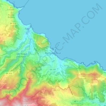
Name: Porto da Cruz topographic map, elevation, terrain.
Location: Porto da Cruz, Machico, Madeira, 9225-250, Portugal (32.73251 -16.86860 32.81251 -16.78860)
Average elevation: 244 m
Minimum elevation: -3 m
Maximum elevation: 1,082 m
Make a donation
Gear up for your next adventure:
As an Amazon Associate, this site earns from qualifying purchases at no extra cost to you.