
Make a donation
Gear up for your next adventure:
As an Amazon Associate, this site earns from qualifying purchases at no extra cost to you.
Hohenbocka topographic map
Click on the map to display elevation.
Make a donation
Gear up for your next adventure:
As an Amazon Associate, this site earns from qualifying purchases at no extra cost to you.
About this map
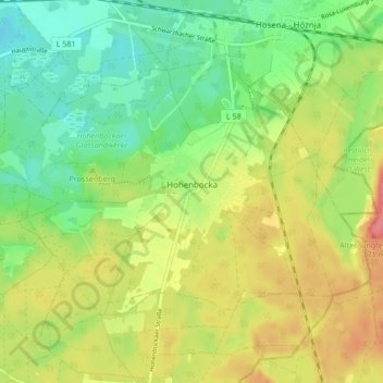
Name: Hohenbocka topographic map, elevation, terrain.
Average elevation: 127 m
Minimum elevation: 96 m
Maximum elevation: 165 m
Make a donation
Gear up for your next adventure:
As an Amazon Associate, this site earns from qualifying purchases at no extra cost to you.
Other topographic maps
Click on a map to view its topography, its elevation and its terrain.
Weißag
Deutschland > Brandenburg > Oberspreewald-Lausitz > Luckaitztal
Weißag liegt am südlichen Rand der Calauer Schweiz. Nördlich des Ortes liegen die sogenannten Weißager Berge, deren höchste „Erhebung“ der Spitzberg mit einer Höhe von 144 m ü. NHN ist.
Average elevation: 127 m