
Make a donation
Gear up for your next adventure:
As an Amazon Associate, this site earns from qualifying purchases at no extra cost to you.
Loppem topographic map
Click on the map to display elevation.
Make a donation
Gear up for your next adventure:
As an Amazon Associate, this site earns from qualifying purchases at no extra cost to you.
Loppem
Loppem ligt in Zandig Vlaanderen op een hoogte van ongeveer 8 meter. Er zijn veel kastelen met landgoed. De belangrijkste beek is de Kerkebeek waarin ter hoogte van Loppem de Rollegembeek uitmondt. Deze beken stromen in noordelijke richting.
Make a donation
Gear up for your next adventure:
As an Amazon Associate, this site earns from qualifying purchases at no extra cost to you.
About this map
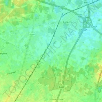
Name: Loppem topographic map, elevation, terrain.
Location: Loppem, Zedelgem, Brugge, West-Vlaanderen, 8210, België (51.11310 3.14741 51.16737 3.21523)
Average elevation: 10 m
Minimum elevation: 1 m
Maximum elevation: 22 m
Make a donation
Gear up for your next adventure:
As an Amazon Associate, this site earns from qualifying purchases at no extra cost to you.
Other topographic maps
Click on a map to view its topography, its elevation and its terrain.
Zedelgem
België > West-Vlaanderen > Brugge > Zedelgem
Zedelgem behoort tot Zandig Vlaanderen en de kom ligt op een hoogte van ongeveer 12 meter, terwijl de hoogte van de omgeving varieert van 9 tot 20 meter. De Plaatsebeek stroomt door het centrum en de Zabbeek stroomt iets ten noorden daarvan.
Average elevation: 12 m