
Thank you for supporting this site ❤️
Make a donation
Make a donation
Gear up for your next adventure:
As an Amazon Associate, this site earns from qualifying purchases at no extra cost to you.
Setecoros topographic map
Click on the map to display elevation.
Thank you for supporting this site ❤️
Make a donation
Make a donation
Gear up for your next adventure:
As an Amazon Associate, this site earns from qualifying purchases at no extra cost to you.
About this map
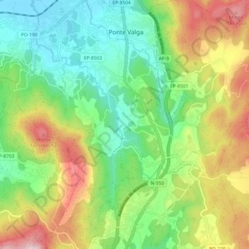
Name: Setecoros topographic map, elevation, terrain.
Location: Setecoros, Valga, Caldas, Pontevedra, Galicia, España (42.65885 -8.68818 42.69272 -8.59911)
Average elevation: 162 m
Minimum elevation: 1 m
Maximum elevation: 429 m
Thank you for supporting this site ❤️
Make a donation
Make a donation
Gear up for your next adventure:
As an Amazon Associate, this site earns from qualifying purchases at no extra cost to you.