
Canggu topographic map
Click on the map to display elevation.
About this map
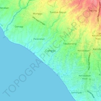
Name: Canggu topographic map, elevation, terrain.
Location: Canggu, Badung, Bali, Lesser Sunda Islands, 08456, Indonesia (-8.69062 115.09650 -8.61062 115.17650)
Average elevation: 20 m
Minimum elevation: 0 m
Maximum elevation: 82 m
Other topographic maps
Click on a map to view its topography, its elevation and its terrain.
Pecatu
Pecatu is located in South Kuta District of the Badung Regency. It is at the western end of the Bukit Peninsula in south Bali, and has a hilly topography with limestone cliffs isolating small, short beaches that have been privately developed. Nusa Dua, on the opposite side of the peninsula, is flat and is a…
Average elevation: 65 m
Ayung River
The Ayung River watershed area has an annual average temperature between 18.4 °C and 26.6 °C, depending on the altitude. The average annual rainfall at the upstream is high, around 1963–3242 mm. Going downstream at an average inclination of 13.13%, the rainfall and the rainy days on the river decrease. In…
Average elevation: 444 m