
Make a donation
Gear up for your next adventure:
As an Amazon Associate, this site earns from qualifying purchases at no extra cost to you.
Saint Petersburg topographic map
Click on the map to display elevation.
Make a donation
Gear up for your next adventure:
As an Amazon Associate, this site earns from qualifying purchases at no extra cost to you.
Saint Petersburg
The elevation of Saint Petersburg ranges from the sea level to its highest point of 175.9 m (577 ft) at the Orekhovaya Hill in the Duderhof Heights in the south. Part of the city's territory west of Liteyny Prospekt is no higher than 4 m (13 ft) above sea level, and has suffered from numerous floods. Floods in Saint Petersburg are triggered by a long wave in the Baltic Sea, caused by meteorological conditions, winds and shallowness of the Neva Bay. The five most disastrous floods occurred in 1824 (4.21 m or 13 ft 10 in above sea level, during which over 300 buildings were destroyed); 1924 (3.8 m, 12 ft 6 in); 1777 (3.21 m, 10 ft 6 in); 1955 (2.93 m, 9 ft 7 in); and 1975 (2.81 m, 9 ft 3 in). To prevent floods, the Saint Petersburg Dam has been constructed.
Make a donation
Gear up for your next adventure:
As an Amazon Associate, this site earns from qualifying purchases at no extra cost to you.
About this map
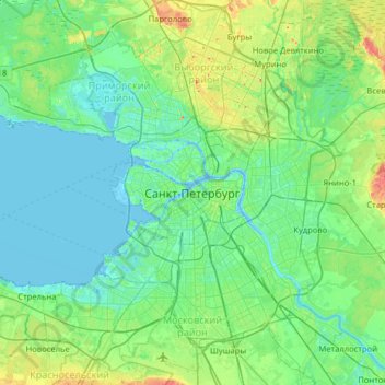
Name: Saint Petersburg topographic map, elevation, terrain.
Average elevation: 14 m
Minimum elevation: -3 m
Maximum elevation: 73 m
Make a donation
Gear up for your next adventure:
As an Amazon Associate, this site earns from qualifying purchases at no extra cost to you.
Other topographic maps
Click on a map to view its topography, its elevation and its terrain.