Geolocate

Centre topographic map

Click on the map to display elevation.

About this map

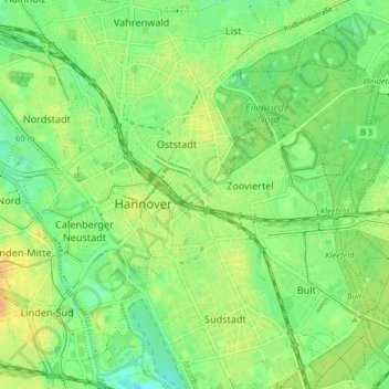
Name: Centre topographic map, elevation, terrain.

Location: Centre, Hanover, Region Hannover, Lower Saxony, Germany (52.35305 9.71195 52.39832 9.79163)

Average elevation: 58 m

Minimum elevation: 44 m

Maximum elevation: 74 m

Other topographic maps

Click on a map to view its topography, its elevation and its terrain.

Wall

Germany > Lower Saxony > Region Hannover > Hanover

Average elevation: 55 m

Gear up for your next adventure:

🧥Waterproof Hiking Jacket - Protect yourself from rain and wind while hiking
🦶Hiking Shoe Insoles - Added support for high arches and long days on feet
👟Leg Gaiters - Keep debris, mud, and snow out of your boots
🥾Hiking Boots - Sturdy boots providing ankle support and traction on rugged trails
🧰Multitool Knife - Compact and versatile tool for outdoor use

As an Amazon Associate, this site earns from qualifying purchases at no extra cost to you.