
Make a donation
Gear up for your next adventure:
As an Amazon Associate, this site earns from qualifying purchases at no extra cost to you.
Le Grand Suchet topographic map
Click on the map to display elevation.
Make a donation
Gear up for your next adventure:
As an Amazon Associate, this site earns from qualifying purchases at no extra cost to you.
Le Grand Suchet
Le Grand Suchet est un cône pyroclastique dont le sommet couronné par un cratère volcanique très peu marqué culmine à 1 231 mètres d'altitude,. Un deuxième sommet, non nommé et constitué du rebord opposé du cratère, s'élève à 1 199 mètres d'altitude. La végétation boisée recouvre ses pentes régulières jusqu'à mi-hauteur, à une altitude approximative de 1 150 mètres.
Make a donation
Gear up for your next adventure:
As an Amazon Associate, this site earns from qualifying purchases at no extra cost to you.
About this map
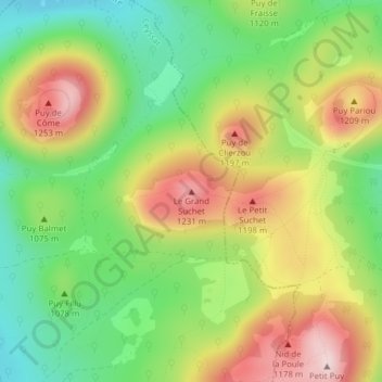
Name: Le Grand Suchet topographic map, elevation, terrain.
Average elevation: 1,079 m
Minimum elevation: 937 m
Maximum elevation: 1,253 m
Make a donation
Gear up for your next adventure:
As an Amazon Associate, this site earns from qualifying purchases at no extra cost to you.