Geolocate

Cuena topographic map

Click on the map to display elevation.

About this map

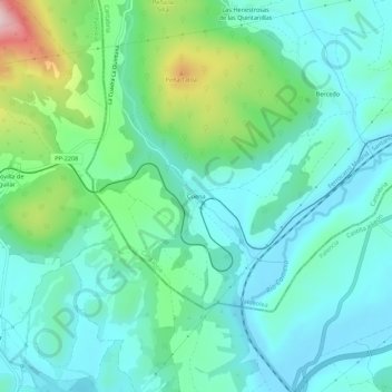
Name: Cuena topographic map, elevation, terrain.

Location: Cuena, Valdeolea, Campoo-Los Valles, Cantabria, 39418, España (42.83633 -4.23031 42.87633 -4.19031)

Average elevation: 973 m

Minimum elevation: 905 m

Maximum elevation: 1,205 m

Gear up for your next adventure:

👟Trail Running Shoes - Agile footwear for fast-paced topographic exploration
🧦Outdoor Socks - Durable socks designed for hiking and outdoor sports
🧥Fleece Jacket - Warm and lightweight jacket for layering
🥾Waterproof Trail Shoes - Shoes designed to handle wet terrain
🦌Outdoor Trail Camera - Monitor wildlife activity near your favorite spots

As an Amazon Associate, this site earns from qualifying purchases at no extra cost to you.