
Lancaster County topographic map
Interactive map
Click on the map to display elevation.
About this map
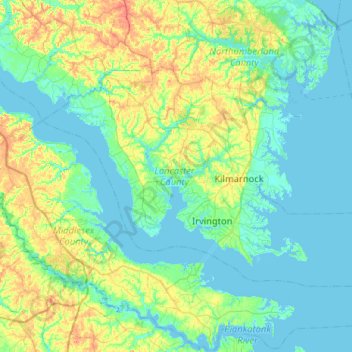
Name: Lancaster County topographic map, elevation, terrain.
Location: Lancaster County, Virginia, United States (37.58508 -76.66818 37.84121 -76.15174)
Average elevation: 13 m
Minimum elevation: -5 m
Maximum elevation: 55 m
Other topographic maps
Click on a map to view its topography, its elevation and its terrain.
McNeals Corner
United States > Virginia > Lancaster County
McNeals Corner, Lancaster County, Virginia, 22507, United States
Average elevation: 22 m
Ottoman
United States > Virginia > Lancaster County
Ottoman, Lancaster County, Virginia, 22517, United States
Average elevation: 10 m