Geolocate

Angers topographic map

Click on the map to display elevation.

👉 Easily get elevation data in JSON, GeoTIFF and KML formats using Elevation API
Thank you for supporting this site ❤️
Make a donation

Angers

Elevation varies 12 to 64 meters (39 to 210 ft) above sea level.

About this map

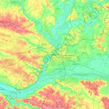
Name: Angers topographic map, elevation, terrain.

Location: Angers, Maine-et-Loire, Pays de la Loire, Metropolitan France, 49100, France (47.31399 -0.71156 47.63399 -0.39156)

Average elevation: 44 m

Minimum elevation: 8 m

Maximum elevation: 106 m

Gear up for your next adventure:

🥾Lightweight Hiking Shoes - Comfortable shoes for day hikes
🔭Outdoor Binoculars - Lightweight binoculars for birdwatching and hiking
🥾Mountaineering Boots - Supportive boots for climbing and high-altitude hiking
🥘Camping Cookware Set - Compact nesting pots and pans for trail cooking
🩹Compact First Aid Kit - Pre-packed essentials for common trail injuries

As an Amazon Associate, this site earns from qualifying purchases at no extra cost to you.