Geolocate

Deggingen topographic map

Click on the map to display elevation.

Deggingen

The municipality (Gemeinde) of Deggingen is found in the district of Göppingen, in Baden-Württemberg, one of the 16 States of the Federal Republic of Germany. Deggingen is physically located in the upper Fils river valley, in the Filsalb region of the Middle Kuppenalb . Elevation above sea level in the municipal area ranges from a high of 777 meters (2,549 ft) Normalnull (NN) to a low of 465 meters (1,526 ft) NN.

About this map
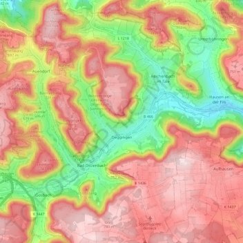
Name: Deggingen topographic map, elevation, terrain.

Location: Deggingen, Vereinbarte Verwaltungsgemeinschaft der Gemeinde Deggingen, Landkreis Göppingen, Baden-Württemberg, 73326, Germany (48.56308 9.68717 48.63925 9.75146)

Average elevation: 643 m

Minimum elevation: 456 m

Maximum elevation: 787 m

Gear up for your next adventure:

🧦Merino Wool Socks - Moisture-wicking comfort for long-distance hiking
🥾Hiking Shorts - Breathable shorts suitable for summer hikes
🔦UV Flashlight - Detect minerals or specific insects in the dark
⛺Family Camping Tent - Spacious tent suitable for family camping trips
💡LED Headlamp - Hands-free illumination for night hiking and camping

As an Amazon Associate, this site earns from qualifying purchases at no extra cost to you.