
Make a donation
Gear up for your next adventure:
As an Amazon Associate, this site earns from qualifying purchases at no extra cost to you.
Itaporã topographic map
Click on the map to display elevation.
Make a donation
Gear up for your next adventure:
As an Amazon Associate, this site earns from qualifying purchases at no extra cost to you.
Itaporã
Está a uma altitude de 390 m. O município de Itaporã encontra-se na Região dos Planaltos Arenítico-Basálticos Interiores. Apresenta relevo plano, geralmente elaborado por várias fases de retomada erosiva, com relevos elaborados pela ação fluvial e áreas planas resultante de acumulação fluvial sujeita a inundações periódicas.
Make a donation
Gear up for your next adventure:
As an Amazon Associate, this site earns from qualifying purchases at no extra cost to you.
About this map
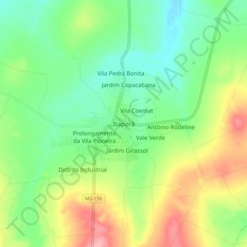
Name: Itaporã topographic map, elevation, terrain.
Average elevation: 364 m
Minimum elevation: 319 m
Maximum elevation: 441 m
Make a donation
Gear up for your next adventure:
As an Amazon Associate, this site earns from qualifying purchases at no extra cost to you.