
Make a donation
Gear up for your next adventure:
As an Amazon Associate, this site earns from qualifying purchases at no extra cost to you.
Twee-Akren topographic map
Click on the map to display elevation.
Make a donation
Gear up for your next adventure:
As an Amazon Associate, this site earns from qualifying purchases at no extra cost to you.
Twee-Akren
Twee-Akren ligt aan de Dender ten noorden van de uitmonding van de Tordoir. De hoogte bedraagt 27 meter. Nabij Twee-Akren likt het Akrenbos, een ongeveer 210 ha groot bosgebied dat vlak bij het Bois Bara in Woelingen is gelegen.
Make a donation
Gear up for your next adventure:
As an Amazon Associate, this site earns from qualifying purchases at no extra cost to you.
About this map
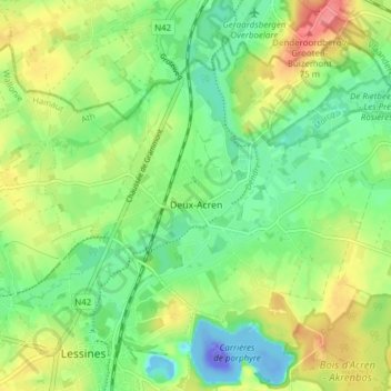
Name: Twee-Akren topographic map, elevation, terrain.
Location: Twee-Akren, Lessen, Aat, Henegouwen, Wallonië, 7864, België (50.71217 3.82258 50.75161 3.89908)
Average elevation: 29 m
Minimum elevation: -110 m
Maximum elevation: 77 m
Make a donation
Gear up for your next adventure:
As an Amazon Associate, this site earns from qualifying purchases at no extra cost to you.