Geolocate

Éibar topographic map

Click on the map to display elevation.

About this map

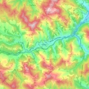
Name: Éibar topographic map, elevation, terrain.

Location: Éibar, Bajo Deba, Guipúzcoa, País Vasco, 20600, España (43.14428 -2.51327 43.22428 -2.43327)

Average elevation: 376 m

Minimum elevation: 44 m

Maximum elevation: 768 m

Other topographic maps

Click on a map to view its topography, its elevation and its terrain.

Trango

España > País Vasco > Bajo Deba > Éibar

Average elevation: 469 m

Gear up for your next adventure:

🧢Beanie Hat - Keep your head warm in cold weather
🧥Ultralight Puffy Jacket - Maximum warmth that packs down to the size of an orange
🥾Light Trekking Boots - Supportive boots for multi-day treks
Tent Footprint - Protect tent floor and increase durability
🧣Merino Neck Gaiter - Protects against wind, sun, and cold at high altitudes

As an Amazon Associate, this site earns from qualifying purchases at no extra cost to you.