Geolocate

St George topographic map

Click on the map to display elevation.

About this map

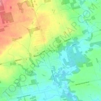
Name: St George topographic map, elevation, terrain.

Location: St George, Brant County, Ontario, N0E 1N0, Canada (43.22530 -80.27086 43.26530 -80.23086)

Average elevation: 241 m

Minimum elevation: 203 m

Maximum elevation: 299 m

Brant County trails, hiking, mountain biking, running and outdoor activities

Gear up for your next adventure:

🗺️Topographic Maps - Detailed maps to explore trails, mountains, and wilderness areas
👟Trail Running Shoes - Agile footwear for fast-paced topographic exploration
🧦Merino Wool Socks - Moisture-wicking comfort for long-distance hiking
🎒Backpack Rain Cover - External shield to keep your entire pack dry
🕶️Polarized Sunglasses - Reduces glare from snow and water at high elevations

As an Amazon Associate, this site earns from qualifying purchases at no extra cost to you.