Geolocate

Hochries topographic map

Click on the map to display elevation.

Hochries

Der Gipfel ist per Bahn von Grainbach aus zu erreichen. Vom Ort geht ein Sessellift zur Mittelstation auf 920 m Höhe. Von dort führt eine Kabinenbahn auf den Gipfel. Die Hochries ist als Rosenheimer „Hausberg“ beliebt bei Wanderern sowie insbesondere Gleitschirm- und Drachenfliegern.

Wikipedia (CC-BY-SA 3.0)

About this map

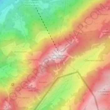
Name: Hochries topographic map, elevation, terrain.

Location: Hochries, Samerberg, Landkreis Rosenheim, Bayern, 83122, Deutschland (47.74710 12.24868 47.74720 12.24878)

Average elevation: 1,223 m

Minimum elevation: 787 m

Maximum elevation: 1,559 m

Gear up for your next adventure:

🧴Sunscreen SPF - Broad-spectrum sunscreen for outdoor activities
🥾Mountain Trail Shoes - High-traction shoes for mountain trails
🥽Outdoor Goggles - Protective eyewear for outdoor activities
🏃Hydration Running Vest - Carry water and maps close to your body for speed
🧥Waterproof Pants - Keep dry during rainy hiking conditions

As an Amazon Associate, this site earns from qualifying purchases at no extra cost to you.